

Map Type
American Indian Groups
Data Source
U.S. Census Bureau, 2008-2012 American Community Survey 5-Year Estimates
Data Source Date
2012
Creation Date
2014
Preview
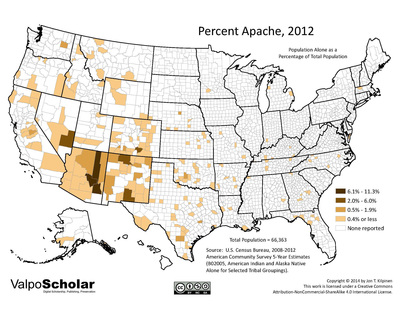
Description
County-level map of Apache population in the United States, 2012
Recommended Citation
Kilpinen, Jon T., 2014. "Percent Apache, 2012." United States Map Gallery. Map 02.02. http://scholar.valpo.edu/usmaps/29
2.02_pct_apache_2012.pdf (2367 kB)
PDF full version
PDF full version
Keywords
U.S. Census, American Community Survey, American Indian, Native American, Apache, tribe, geography, map