

Map Type
Race, Ethnic, and Minority Groups
Data Source
U.S. Census Bureau
Data Source Date
2010
Creation Date
2014
Preview
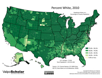
Description
County-level map of white population in the United States, 2010
Recommended Citation
Kilpinen, Jon T., 2014. "Percent White, 2010." United States Map Gallery. Map 01.06. http://scholar.valpo.edu/usmaps/11
1.06_white_2010.pdf (2371 kB)
PDF full version
PDF full version
Keywords
U.S. Census, white, ethnicity, geography, map