

Map Type
Socio-Economics
Data Source
U.S. Census Bureau
Data Source Date
2010
Creation Date
2014
Preview
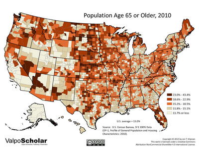
Description
County-level map of the United States' population age 65 or older in 2010
Recommended Citation
Kilpinen, Jon T., 2014. "Population Age 65 or Older, 2010." United States Map Gallery. Map 12.05. http://scholar.valpo.edu/usmaps/100
12.05_over_64_2010.pdf (2579 kB)
PDF full version
PDF full version
Keywords
U.S. Census, United States, choropleth, geography, map, ValpoScholar, population, age